|
|
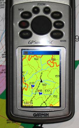
Now THIS
Changes Everything!!! Like a lot of Woodlot Licencees, I bought
a recreation grade GPS to help navigate in my Woodlot. The GPS worked fine, but when I asked “How
do I get my forest cover maps into it?” the answer I got was “You
can’t”. Well, after a lot of R&D,
it turns out “Yes, you can!” Reconnaissance and development planning are
a treat when you are armed with a scrolling color map of your woodlot with a
real time “You Are Here” arrow. You
can walk to the heart of any polygon for inventory work. And you can record data points at will for
recce level traverses of road locations, block boundaries, or whatever. The whole rig has paid for itself in a
month by erasing the hours (and legwork!) spent tying in, and then traversing
through windfall and up rock faces to get to work areas. You want this! We can convert your maps into Garmin GPS format. Paper or digital, we can do it. Woodlot Forestry Services Ltd. Mapping and Development Tom Bradley (250) 226-7792 tomb@netidea.com www.woodfor.com |